"Tuckahoe" in 1878 - Close Up
(Description Below)
How It Looked When Douglass Returned
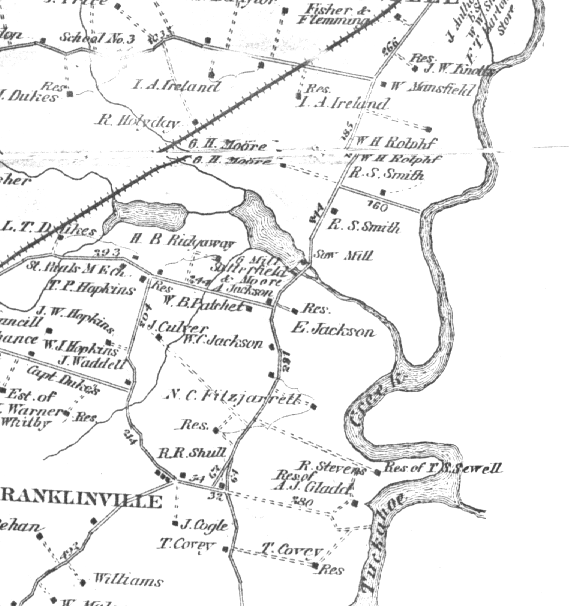
The map above was created as part of a Centennial survey, census, and mapping project in 1876, two years before Frederick Douglass returned to his birthplace. It marks many of the local features that Douglass saw in 1878. He hired a carriage for the drive from Easton, got out at Tapper's Corner, and "surveyed the lay of the land" in search of "Aunt Bettie's Lot", where his grandmother's cabin had stood.
Douglass probably travelled from Easton through the town of Cordova. From Cordova to Tapper's Corner, he probably followed the road that diverges from the railroad tracks at the left edge of the map. Tapper's Corner is marked today by a small, privately-made sign that stands at the road junction next to the house marked "A. Jackson" on the map. Douglass dismounted from the carriage and looked toward the two-story farmhouse of "E. Jackson", also marked on the map. The new Jackson home stood on the site where the hired steward of Douglass' master, Aaron Anthony, had lived. When the farm belonged to Anthony, he called it "Holme Hill".
Douglass' eyes followed the line between plowed fields and woods, looking for the cabin site. The woodline marks the creek running from the "Saw Mill" north of E. Jackson's to "Tuckahoe Creek". You can also see "G. Mill" labeled at the pond - probably meaning "grist mill", known as Lee's Grist Mill, during Douglass' childhood. In 1878, "Tuckahoe Creek" still served as a steamboat route that connected Hillsboro (where master Anthony died in 1824) and its sister town, Queen Anne, to Baltimore and Washington, D.C. From the west bank of the Tuckahoe, halfway between the residences of "E. Jackson" and "N.C. Fitzjarrell", Douglass saw a wooded ravine that ran toward Tapper's Corner, where he stood. This ravine was called "Kentucky" when he was a child. Probably near its head was a spring from which his family drew water. Douglass also remembered a cedar tree which, to his delight, he found in the woods near what was still known locally as "Aunt Bettie's Lot" -- a reference to the cabin site of his grandmother, Betsey Bailey -- more than 40 years after her death.
The road stretching north and west of A. Jackson's residence at Tapper's Corner is today's Md. Route 303. Lewistown Road runs south from this same spot. Md. Route 309 now runs along the railroad tracks. The tracks still exist, serving the struggling "Chesapeake Railroad", operated by a local entrepeneur. The ponds at the "Saw Mill" have been drained. But you can still see ruins of a concrete dam and spillway that date from the period after Douglass' childhood on the Anthony farm.
|


